 MineArchive
Easdale Slate Quarries
| Also known as | Eisdeal, Easdale Island Quarries |
|---|---|
| Location | Easdale Island, Argyll and Bute — 56.2926, -5.6594 (exact) |
| Commodity | Slate |
| Type | Slate |
| Worked | 1745–1911 |
| Maximum depth | 250 ft (about 76 m) below tide level |
| Operators | Marble and Slate Company of Netherlorn (1745–1881) |
Overview
Easdale, one of Argyll's Slate Islands off Seil, was quarried for roofing slate on an industrial scale from 1745, at its peak producing around 10 million slates a year — enough that the islands were said to have "roofed the world". The industry ended abruptly on Easdale itself when a violent storm breached a sea wall in November 1881 and flooded the quarries, which had been worked to 250 feet below tide level; 240 men and boys lost their jobs overnight, though no one was hurt.
History
A cargo of Easdale slate is recorded as early as 1168, but organised quarrying dates from 1745, when the Earl of Breadalbane's Marble and Slate Company of Netherlorn took over the workings. The island came to hold as many as seven working quarries, some reaching far below sea level. Output grew rapidly: around one million slates a year in the mid-18th century, five million by 1800 — helped by pumping machinery that made it possible to work seams below sea level even at high tide — and a peak of roughly ten million slates a year by the late 19th century, from quarries on Easdale and the neighbouring islands of Seil, Luing and Belnahua. The slate went to Glasgow, to Ireland and beyond, and gave its name to the Easdale slate of the trade. An 1799 tax on slate carried by sea cut into profits well before the quarries' more dramatic end.
Geology
The quarries worked Dalradian slate of the kind found across Argyll's Slate Islands, extracted from pits sunk close to and below current sea level, protected from the sea by rock and man-made sea walls.
Geological setting: Slate and Regional Metamorphism (well documented example)
Workings
Workings were sunk as open pits rather than driven underground, reaching 250 feet below tide level on Easdale by 1881; continuous pumping was needed to keep the sea out of pits that extended below the surrounding water level.
Closure
In the early hours of 22 November 1881, a severe south-westerly gale coincided with an exceptionally high tide; a rocky buttress supporting one of the sea walls gave way under the pressure, and by daybreak the quarry — worked to 250 feet below tide level — was flooded beyond what even its large suction pump could clear. No one was killed or injured, as the island's inhabitants had already moved to higher ground, but 240 men and boys were thrown out of work, and the flooded workings on Easdale itself were abandoned for good; the last slate was cut there in 1911, though quarrying continued on the neighbouring Slate Islands into the 1950s. The island's population, over 500 at the industry's peak, had fallen to just four residents by the 1960s.
What remains
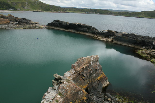
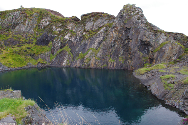
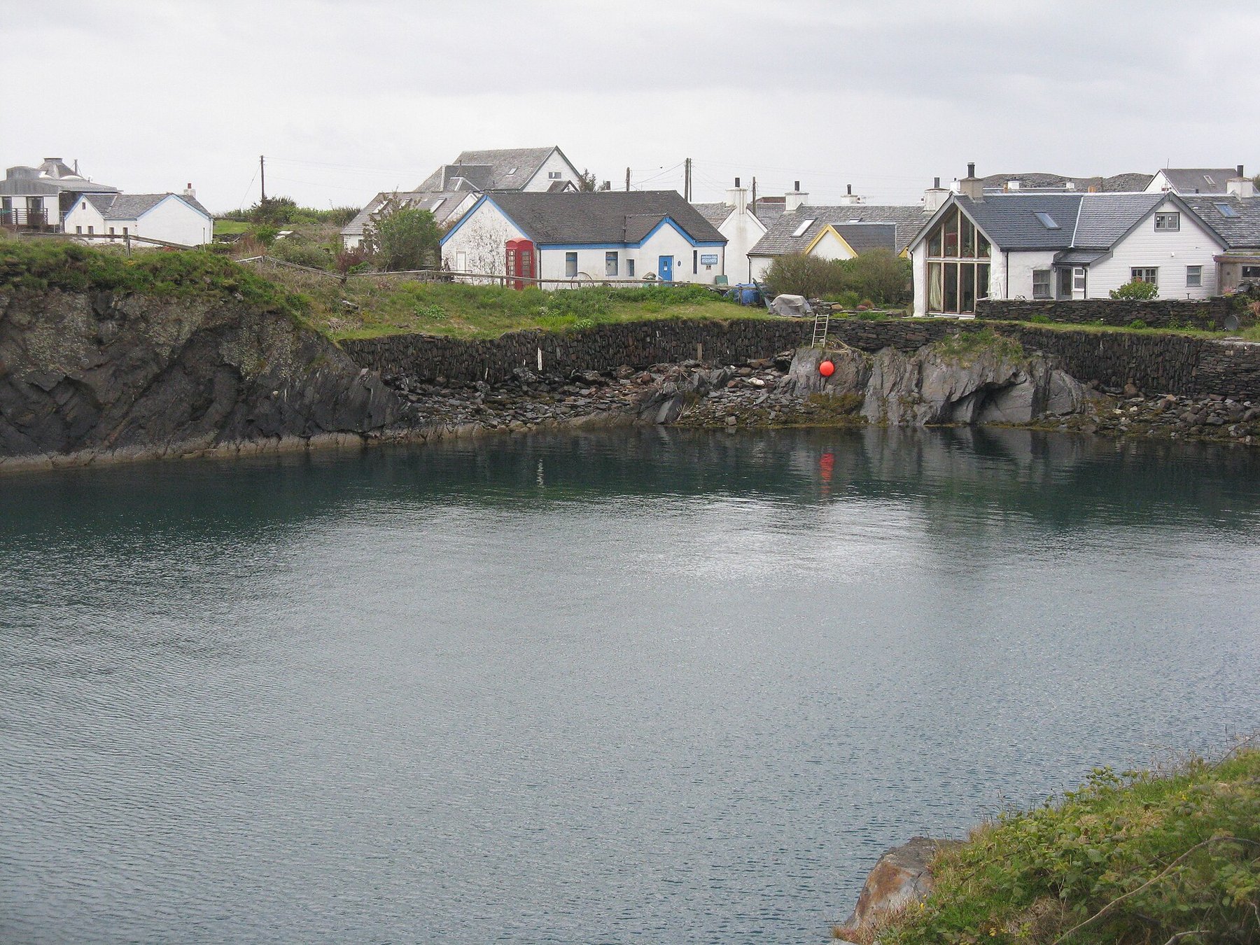
The flooded quarry pits now form a series of still pools across the island that support wildlife, and the Easdale Island Folk Museum preserves artefacts, documents and photographs from the slate industry. The island did not stay empty: from the four residents of the early 1960s the population has climbed steadily again, most of the houses have been rebuilt and modernised, and the island's economy now rests on tourism, on people working in Oban and on the mainland, and on businesses run from home over broadband. The museum draws over five thousand visitors a year, and there is a pub and restaurant; the former drill hall was bought in 1996 by an island resident and handed to the community charity Eilean Eisdeal.
The quarry pits themselves, flooded, with the spoil and working faces around them — the sources note that barely a square inch of the island has been left unaffected by quarrying.
Redevelopment
No redevelopment of the workings: the pits remain open water. The island around them has been rebuilt as a residential and tourist community, with the folk museum and the community-owned former drill hall.
Related mines
- Ballachulish Slate Quarries — Historic Scotland's heritage management team names Ballachulish and Easdale as Scotland's two slate 'super quarries' of the late nineteenth century — the pair that between them roofed much of the country, and the comparison by which Ballachulish's national significance is judged.
- Belnahua Slate Quarries — Neighbouring Slate Islands quarries in the Firth of Lorn, both ended by the collapse of the slate trade before the First World War.
- Luing Slate Quarries — Neighbouring Slate Islands quarries worked by the same company, the Earl of Breadalbane's Marble and Slate Company of Netherlorn, and counted together in the output that was said to have roofed the world.
Nearby mines
- Belnahua Slate Quarries — 3.1 miles (4.9 km) SW
- Luing Slate Quarries — 4.5 miles (7.2 km) S
Straight-line distance, within 9 miles (15 km). Show on the map.
The flooded former quarry pits are steep-sided and deep — this entry describes history and general location only, not an access guide.
What's uncertain
Points where sources disagree or the record could not be settled; both accounts are kept. All open questions in the archive.
- The record's own account and the scheduling text give 250 feet below tide level for the quarry flooded in 1881; easdale.org says some of the island's seven quarries extended to 300 feet below sea level. (disputed) 1,2
Recorded claims
Individual factual claims, each attached to the source(s) that support it below. Where sources disagree, both are kept.
- Output grew from around one million slates a year in the mid-18th century to five million by 1800 and a peak of roughly ten million a year by the late 19th century. 1,2
- A severe gale and exceptionally high tide breached a sea wall on 22 November 1881, flooding the Easdale quarry (worked to 250 ft below tide level); 240 men and boys lost their jobs, but no one was killed or injured. 2,3
- Easdale's population, over 500 at the slate industry's peak, had fallen to just four residents by the 1960s. 2
- The record's own account and the scheduling text give 250 feet below tide level for the quarry flooded in 1881; easdale.org says some of the island's seven quarries extended to 300 feet below sea level. (disputed) 1,2
- The island had as many as seven working quarries, and together with those on the neighbouring islands of Seil, Luing and Belnahua gave its name to Easdale slate, which was exported to Glasgow, Ireland and beyond. 2
- From four residents in the early 1960s the population has increased steadily; most houses have been rebuilt, tourism is the main industry, and the museum attracts over five thousand visitors a year. 2
Photographs & further reading
The island community's own account of the seven quarries, the 1881 storm, the collapse to four residents by the 1960s and the recovery since.
View sourceSources
- (secondary) Slate Industry — Easdale Island Folk Museum
- (secondary) Easdale Island Historical Background — Eilean Eisdeal (Easdale community history)
- (secondary) Easdale, slate quarries and associated workings — ancientmonuments.uk
Record created: 20 August 2026 · Last researched: 9 September 2026