 MineArchive
Cawfields Quarry
| Also known as | Cawfield Quarry |
|---|---|
| Location | Hole Gap, near Haltwhistle, Northumberland — 54.9936, -2.4478 (approximate) |
| Commodity | Whinstone |
| Type | Quarry |
| Worked | from 1902 |
| Operators | Alston Limestone Company Ltd (owner) — Owners in the 1930s (Durham Mining Museum) |
A whinstone quarry cut through the Great Whin Sill and Hadrian's Wall at Hole Gap near Haltwhistle from 1902, now a pond and picnic site below Milecastle 42.
Location
Approximate location. The large pin is this mine; the small round markers are the nearest mines on record. Click one for its page. View on full map
History
Cawfields Quarry was cut into the Great Whin Sill at Hole Gap, west of Haltwhistle, right on the line of Hadrian's Wall. Working began in 1902 and went straight through the crags and the Roman Wall along their top, destroying a large stretch of it; the quarry stopped short of Milecastle 42, which still stands on the slope beside it. In 1905 it employed 51 people, nearly all at the face, and in 1922, 34. The Alston Limestone Company had it in the 1930s.
For years the Wall at Cawfields was threatened or damaged by quarrying, and only after a long campaign were the remains on Cawfields Crags taken into state guardianship, in 1960. They were uncovered and conserved between 1960 and 1973. The quarry has since become a picnic site around a large pond, with the cut face of the sill rising behind it: a rather peaceful end for the thing that took a bite out of the Wall.
Geology
Dolerite of the Great Whin Sill, with near-vertical jointing in the quarry face.
Workings
An open quarry cut through the crest of the Whin Sill crags, removing the scarp and the Wall along it.
What remains
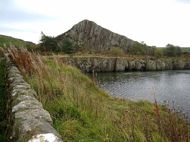
Flooded to form a large pond, with the quarry face of the sill exposed; the site is a picnic area beside the Hadrian's Wall path.
The quarry face and pond.
Redevelopment
Landscaped as a picnic site.
Nearby mines
- South Tyne Colliery — 1.2 miles (2.0 km) S
- Bayldon Colliery — 1.8 miles (2.9 km) SE
- Blackett Colliery — 1.8 miles (2.9 km) S
- Melkridge Colliery — 1.8 miles (2.9 km) SE
- Wallshield Colliery — 2.2 miles (3.6 km) N
Straight-line distance, within 9 miles (15 km).
Further reading
English Heritage's history of the Wall at Cawfields: the quarry's destruction of the Wall from 1902 and the guardianship of 1960.
View sourceThe site today: a former quarry cut through the Wall and the Whin Sill, now a pond and picnic site.
View sourceSources
- (secondary) History of Cawfields Wall, Milecastle and Turret (English Heritage) — English Heritage
- (secondary) Cawfields Quarry Picnic Site and Milecastle 42 (Hadrian's Wall Country) — Hadrian's Wall Country
- (primary) Cawfields Quarry (Durham Mining Museum) — Durham Mining Museum
- (observational) Cawfields Quarry (Geograph) — Geograph
Record created: 20 November 2026 · Last researched: 20 November 2026