 MineArchive
Park Lime Pits
| Location | Rushall, north-east of Walsall, West Midlands — 52.5954, -1.9584 (approximate) |
|---|---|
| Commodity | Limestone |
| Type | Quarry |
| Worked | By the early 19th century–By the 1870s |
| Maximum depth | Unknown. |
Overview
Limestone quarries in the park of Rushall Hall, north-east of Walsall, which fed the iron furnaces of the Black Country and were landscaped by the Victorians into the two flooded pools that are now a Local Nature Reserve.
History
Limestone of high quality lies close to the surface at Rushall, north-east of Walsall, and it was worked there for building and for agriculture from Roman times and through the Middle Ages. The Black Country Geopark records a suggestion, unproven, that stone from these quarries went into the paving of Watling Street a little to the north. Large-scale extraction came much later. The use of limestone as a flux for smelting iron brought a great expansion of working during the Industrial Revolution, and it is to that period that the pits belong. The bed here is the Wenlock Limestone, the more valuable of the Walsall limestones and the one in demand at the furnaces; the Lower Limestone extends out of Walsall into Rushall, where several limeworks often stated to be in Walsall were in fact situated. A new settlement grew up at Daw End, and the Hay Head and Linley workings nearby were both on a large scale. The quarries that became Park Lime Pits lay inside the park of Rushall Hall, the seat of the Leigh family and afterwards of the absentee Mellish and Buchanan families, whose estate was not finally sold off until 1945. Stone left the pits in pony-drawn rail trucks and by the local canals, which carried it to the iron foundries of the Black Country; the Daw End branch of the Wyrley and Essington Canal, cut in 1800 to serve the limeworks at Hay Head, runs close by the site. The Arboretum lakes at Walsall, then also in Rushall, were formed by quarrying in the same way. Working ceased about a century and a half ago. The Victorians landscaped the old workings, and the abandoned quarries filled with water to become the two pools that occupy the ground today. The lime-rich soils left behind carry over three hundred species of plants, and the site is now a Local Nature Reserve of about five hectares, its pools ringed by mature beech woodland.
Geology
The quarries worked the Wenlock Limestone Formation, part of the Silurian rocks that rise close to the surface around Walsall and Rushall. Three productive limestone beds occur in the district; the Lower Limestone, the more valuable of them and the one wanted as an iron-smelting flux, outcrops around Walsall's Church Hill and the Arboretum and extends eastward into Rushall. The lime-rich soils left on the quarry ground are the reason for the site's botanical interest, with over three hundred plant species recorded and a calcareous grassland flora unusual for the conurbation.
Workings
Open quarries, known locally as the pits, cut into the limestone within the park of Rushall Hall. During the main period of working the stone was moved out in pony-drawn rail trucks and then by canal to the Black Country foundries.
Closure
Quarrying ceased about a century and a half ago, at the end of the district's lime trade. The Victorians then landscaped the old workings, which filled with water to form the pools.
What remains
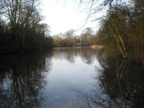
A Local Nature Reserve of about five hectares under Walsall Metropolitan Borough Council, with two clear pools surrounded by mature beech woodland and species-rich calcareous grassland and meadow. More than a hundred bird species have been recorded. A circular route runs through the reserve, linking to the Lime Pits Farm walk, and there is a pond-dipping platform on the small pool; fishing is permitted on the large pool only. A walker in 2014 described a nature trail through the woods with views out over the surrounding farmland.
The quarries themselves survive as the two flooded pools, and the ground between them carries the lime-loving flora that the working left behind. There is no visitor centre or other building on the site.
Redevelopment
The site was laid out as a nature reserve rather than built on, and is a Black Country Global Geopark geosite as well as a Local Nature Reserve.
Related mines
- Hay Head Quarry — The other large Rushall limeworks, on the Barr Limestone a mile and a half south; the Daw End branch canal was cut to serve it.
Nearby mines
- Hay Head Quarry — 2.1 km SE
- Aldridge Colliery — 3.2 km NE, Staffordshire
- Pelsall Hall Colliery — 3.7 km N
- Walsall Wood Colliery — 4.5 km NE, Staffordshire
- Hamstead Colliery — 6.4 km S
Straight-line distance, within 15 km. Show on the map.
What's uncertain
Points where sources disagree or the record could not be settled; both accounts are kept. All open questions in the archive.
- Stone from the quarries may have been used by the Romans for paving on Watling Street to the north of the site, though the suggestion is not established. (uncertain) 1
Recorded claims
Individual factual claims, each attached to the source(s) that support it below. Where sources disagree, both are kept.
- The quarries worked the Wenlock Limestone Formation, which outcrops at the site. 1
- Limestone left the pits in pony-drawn rail trucks and by the local canals, bound for the iron foundries of the Black Country. 1
- The quarries lay within the park of Rushall Hall and flooded after working ceased to become the Park Lime Pits. 2
- Quarrying ceased about a century and a half ago, after which the Victorians landscaped the workings and the quarries flooded to form the pools. 1
- Stone from the quarries may have been used by the Romans for paving on Watling Street to the north of the site, though the suggestion is not established. (uncertain) 1
- The site is a Local Nature Reserve of about five hectares, with two pools in mature beech woodland and over three hundred recorded plant species. 3,4
Photographs & further reading
The Geopark's account of the limestone worked here, how it was moved out, and what the site became.
View sourceWalsall Local History Centre's history of the parish, covering the limestone workings and Rushall Hall.
View sourceSources
- (primary) Park Lime Pits Local Nature Reserve geosite — Black Country UNESCO Global Geopark
- (secondary) Rushall in history — Walsall Local History Centre, Walsall Council
- (primary) Park Lime Pits Local Nature Reserve — Walsall Council
- (secondary) Park Lime Pits — Woodland Trust
- (observational) Rambling Around Rushall — West Midlands Exploration
- (secondary) Walsall: Economic history — Victoria County History of Staffordshire, vol. 17 — Victoria County History
Record created: 23 September 2026 · Last researched: 23 September 2026